The North Sea Trail is our latest discovery for beautimus hiking! If you go west from Bergen an hour by bus, you get to the sea. Bergen itself is protected by the Seven Mountains and Askøy island from the sea. The west coast has a long north-south island with a walking trail along it, winding over rocky outcroppings and around mini-fjords. We saw pictures and decided we had to go there! When Ed bought the maps, the lady told him that the fall colors were spectacular there the previous weekend. Rain was predicted, but they say that it rains here in Bergen, but not out at the coast. So we went to see!
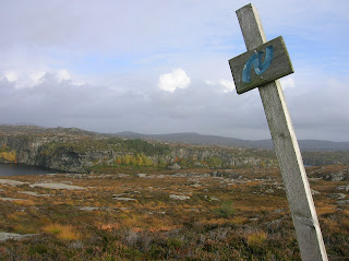
 Wow! The fall colors were wonderful. There are very few trees there, but the bushes and ground cover were all red and yellow and in between. You can see a long way, because it's very flat. The trail is marked with blue wavy Ns on posts or piles of rocks. We stopped every five minutes to take pictures.
 The rocks reminded me of petrified wood. They have the parallel grooves like bark. The trail tries to stay above the wet ground by following the rocks. It winds around a lot, but there are lots of trail markers. I'm standing by one, and there's one behind Ed in the pictures.
 The section we did is only 9 km long, and we had 6 hours before the bus back to Bergen. No problem, right? Wrong. We made a dumb decision when we were almost there. We started following what turns out to be property markers instead of trail markers. They were going north, toward Tælevåg, but then they veered east, and dag nab it, there just were not enough contour lines for us to really get our bearings from our maps! We are used to having mountains to point our compasses at. At 5 pm, with only an hour to go till the last bus, and two hours till sundown, I decided to break down and call for help. We have never in all our hiking had to do that. We gave a good description of the two landmarks we could say we were near - a cairn or 6 foot pile of rocks, and a stream with pipes in it.
The police dispatcher called someone who knows the trail well, and we were told to walk west toward the sea. We would see a big former fish hatchery, and then we would find a gravel road. I would like to point out that there was no road or fish hatchery on our maps!! Anyway, we headed west cross-country, and soon enough, there was a man out waving at us. When we got to him, he held out his hand and said, "Welcome to Tælevåg!" Ed told him he was the best welcoming committee he had ever seen. His name was Trygve, and he had been called by the police dispatcher and had driven out to look for us. He walked us to that magic gravel road, and back toward town, and then took us home with him. (The last bus had already left.) His wife fixed coffee, and we had an absolutely wonderful hour and a half with them. Trigve pulled out his trail maps so he could figure out how we got off the trail and idiot-proof it. To top it off, he and Ed looked at the bus schedule and Trygve figured out a place we could catch a late bus home that was a few miles away, and then he drove us to the bus station. What wonderful people!
Now we have a new strategy for meeting Norwegians - get lost and call for help. We will definitely be back on the North Sea Trail again and again. We also know two important things for hiking: property and trail markers look alike, and more importantly, roads are built along the ocean, not inland!
I like your stategy!
ReplyDeleteHave you done a complete root cause analysis to determine what the critical X's were?
ReplyDeleteOf course, I think I would know where to look first, considering I know a story about a girl scout leader! I know, I know, correlation is not causality, but based on all of the evidence we have to date, even two data points can begin to indicate a trend...
I think it may be time to turn over the leadership to Ed, who being a guy, would quickly ask for directions. Wait, no....
Good Strategy! Nice blog. Thanks for sharing the great photos
ReplyDeleteLinda